Okinawa Prefecture
Southernmost Japanese prefecture, former Ryukyu Kingdom center.

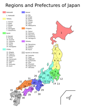
Okinawa Prefecture is the southernmost and westernmost prefecture of Japan, consisting of three main island groups: the Okinawa Islands, the Sakishima Islands, and the Daitō Islands. Historically the center of the Ryukyu Kingdom, it served as a maritime trading hub and cultural gateway, participating in the Chinese tributary system with the Ming and Qing dynasties. After the Ryukyu Disposition in 1879, it was incorporated into Japan, and following the Battle of Okinawa (1945), it was under U.S. administration until reversion in 1972. Today, it hosts a large share of U.S. military facilities in Japan, a continuing source of debate, and has a small but persistent independence movement reflecting its distinct identity.
- location
- Southernmost and westernmost prefecture of Japan
- capital
- Naha
- largest_island
- Okinawa Island
- total_land_area
- 2,281 km² (880 sq mi)
- number_of_islands
- 160 (49 inhabited)
- climate
- Subtropical
- historical_entity
- Center of the Ryukyu Kingdom until 1879
Verified Timeline
Lore & Background
Okinawa Prefecture's prehistoric history differs significantly from mainland Japan, with evidence of human activity dating back approximately 32,000 years (Yamashita Cave Man) and the world's oldest known fishhook discovered in 2012 at the Sakitari Cave site. The Shellmidden Period saw exchanges with Kyushu, as shown by pottery styles and obsidian from Saga Prefecture, but later pottery became distinctly localized. In contrast, the Miyako and Yaeyama Islands were shaped more by southern cultures, including those from the Philippines. From the 12th century, the Gusuku period began, with local chieftains (Aji) constructing fortified residences called Gusuku. By the 14th century, Okinawa Island was divided into three polities: Hokuzan, Chūzan, and Nanzan. In 1372, the Ming dynasty requested tributary relations with Chūzan, and soon all three kingdoms entered the Chinese tributary system. Shō Hashi unified the island by 1429, establishing the First Shō Dynasty. After political instability, the Second Shō Dynasty was founded by Kanemaru (Shō En). Under King Shō Shin, centralized administration was established, and the kingdom expanded from the Amami Islands to the Yaeyama Islands, experiencing a cultural golden age. The Ryukyu Kingdom became a key intermediary trading hub in East Asia, trading with China, Japan, Southeast Asia, and the Korean Peninsula. Its significance declined in the 16th century with the Age of Discovery and China's relaxed maritime prohibitions. The Miyako and Yaeyama Islands were brought under centralized control in the late 15th and early 16th centuries.
Reader's Guide
Okinawa Prefecture holds significance as a region with a distinct historical trajectory, from its prehistoric roots and the Ryukyu Kingdom's role as a maritime trading hub to its incorporation into Japan and post-World War II U.S. administration. Its legacy includes the development of unique traditions, cuisine, and performing arts, such as Okinawan music featuring the sanshin instrument and the Eisa festival. The islands are also the birthplace of karate, later popularized worldwide. The prefecture's economy is predominantly service-based, driven by tourism, while manufacturing plays a small role. The presence of U.S. military facilities, occupying about 10% of the prefecture's total land area and around 70% of the land used exclusively by U.S. forces in Japan, remains a source of local and national debate. A small independence movement persists, reflecting Okinawa's distinct identity. The archaeological record, including the world's oldest fishhook and evidence of ancient trade, underscores its long history of cultural exchange.
Did You Know?
- The world's oldest known fishhook was discovered in 2012 at the Sakitari Cave site in Nanjo City, Okinawa Prefecture.
- Okinawa's territorial extent over surrounding seas makes its total area nearly half the combined size of Honshu, Shikoku, and Kyushu.
- Around 70% of the land area exclusively used by U.S. forces in Japan is located in Okinawa, amounting to about 10% of the prefecture's total land area.
- The Ryukyu Kingdom participated in the Chinese tributary system with the Ming and Qing dynasties before being incorporated into Japan in 1879.
- Karate originated in the Okinawa islands before being popularized on the Japanese mainland and worldwide.
From Feudal Fiefs to Modern Jurisdictions
The transformation of Japan's administrative landscape from feudal domains to the 47 prefectures recognized today was neither instant nor linear. When the Meiji government dismantled the old shogunate-era administration in 1868, it created the first wave of prefectures to replace the bugyō and daikan who had governed territories directly under the shogunate. The following year, the landmark haihan-chiken reform swept away all remaining feudal domains, converting them into prefectures as well. This initially produced more than 300 such units. Through successive waves of territorial consolidation, that number was cut to 72 by the end of 1871 and finally settled at 47 by 1888. In many cases, the resulting borders align with the ancient ritsuryō provinces, giving the modern map a continuity that stretches back centuries and linking today's jurisdictions to a far older territorial imagination.
A Governor, an Assembly, and a Layered Bureaucracy
At the helm of every prefecture sits a directly elected governor, known in Japanese as chiji. This executive is paired with a unicameral assembly, the gikai, whose members serve four-year terms and are responsible for enacting ordinances and approving budgets. Below the prefectural level, the administrative structure has historically been subdivided into cities and districts, with districts further broken into towns and villages. Hokkaidō stands apart with its 14 subprefectures, which function as comprehensive promotion bureaus handling prefectural duties across the vast island. Other prefectures maintain branch offices outside their capitals to carry out similar administrative work. Each jurisdiction also bears its own mon, a heraldic emblem that serves the same identifying purpose as a Western coat of arms, giving every prefecture a distinct visual identity on official documents and public signage.
The Portuguese Word That Outlived the Fiefs
The English term "prefecture" carries an unexpected etymological baggage. Sixteenth-century Portuguese explorers and traders, encountering the fiefdoms of local warlords and families in Japan, applied their own word "prefeitura" to describe these territories. In its original Portuguese sense, the term was closer to "municipality" than to "province," yet the rough translation endured through centuries of political reorganization. The fiefs themselves were dismantled, merged, and restructured repeatedly, eventually receiving legislative governance and oversight under the Meiji state. Today the linguistic echo runs in both directions: Japan uses its own word ken to label Portuguese districts, while in Brazil the word "Prefeitura" designates a city hall. The four modern categories—metropolis, regional prefecture, urban prefecture, and prefecture proper—descend from the Edo-period distinction between bugyō-ruled urban zones and township-ruled rural areas, a division the Meiji government formalized before later consolidating most into a single ken status.
Autonomy in Name, Dependence in Practice
Japan's unitary state structure means that while prefectures handle substantial functions—organizing police forces, supervising and maintaining high schools, running prefectural hospitals, managing roads and waterways, and coordinating urban planning—the central government retains overarching control. Local government expenditure accounts for roughly 70 percent of total government spending, yet the national government still dictates budget parameters, tax rates, and borrowing limits. The 1947 Local Autonomy Law expanded prefectural political power by installing elected governors and parliaments, but in practice most municipalities remain heavily dependent on central funding. This dependency has been worsened in many rural regions by declining populations, a trend that hits the countryside harder and earlier than cities, which can partially offset losses through in-migration. A 2003 proposal by Prime Minister Koizumi to merge the 47 prefectures into roughly ten larger regional states with greater autonomy was ultimately abandoned in 2012, leaving the current structure intact.
Frequently Asked Questions
Who is Okinawa Prefecture?
Okinawa Prefecture is Japan's southernmost and westernmost prefecture, comprising roughly 160 islands (49 of them inhabited) spread across the Okinawa, Sakishima, and Daitō island groups. Its capital is Naha, and it enjoys a subtropical climate that sets it apart from most of the main Japanese archipelago.
What are Okinawa Prefecture's powers/role?
Historically it operated as a maritime trading hub and cultural crossroads, connecting Japan to China through the Ryukyu Kingdom's tributary ties with the Ming and Qing dynasties. In the modern era it also carries a heavy geopolitical role by hosting a large concentration of U.S. military bases.
How does Okinawa Prefecture's story end?
After the brutal Battle of Okinawa in 1945, the prefecture came under U.S. administration for nearly three decades. Its narrative reaches its modern resolution with the 1972 reversion, when sovereignty was formally handed back to Japan.
Why is Okinawa Prefecture important?
It was the political and cultural heart of the Ryukyu Kingdom, a distinct entity that maintained its own diplomatic relationships before being incorporated into Japan in 1879. Its unique heritage, strategic position in the East China Sea, and role as a cultural gateway make it a pivotal node in regional history.
What is Okinawa Prefecture's total land area and largest island?
The prefecture spans approximately 2,281 square kilometers (880 sq mi), with Okinawa Island itself being the largest single landmass within the group.
More in Japanese Prefectures 1-24
Elsewhere in the Japanese Prefectures universe
Spotted an error? Know more?
This is a living reference — every entry is fact-audited, and reader corrections feed straight into our audit queue. Suggest an edit · See this site's audit record