Ōita Prefecture
A Japanese prefecture famed for its hot springs and agricultural products.

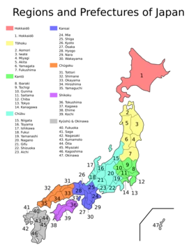
Ōita Prefecture is a prefecture of Japan located on the island of Kyūshū, with a population of 1,081,646 as of 1 February 2025 and a geographic area of 6,340 km². It borders Fukuoka Prefecture to the northwest, Kumamoto Prefecture to the southwest, and Miyazaki Prefecture to the south. Ōita is the capital and largest city. The prefecture is famous for its hot springs and is a popular tourist destination, particularly in and around the city of Beppu, holding more onsen than any other Japanese prefecture.
- Population
- 1,081,646 (1 February 2025)
- Area
- 6,340 km² (2,450 sq mi)
- Capital
- Ōita
- Region
- Kyūshū, Japan
- Known for
- Hot springs (onsen), kabosu limes, dried shiitake mushrooms, saffron
Verified Timeline
Lore & Background
The name Ōita originates from a report in the early 8th-century Chronicles of Bungo. According to the document, when Emperor Keikō visited the Kyushu region, stopping first in Toyo-no-Kuni, he exclaimed that 'This is a vast land, indeed. It shall be known as Okita-Kuni!' Okita-Kuni, meaning 'Land of the Great Fields', later came to be written as 'Ōita'. Present day interpretations state that Oita's name comes from 'Okita', meaning 'many fields', because of Ōita's complex terrain. Around the 6th century, Kyushu consisted of four regions: Tsukushi Province, Hi Province, Kumaso Province and Toyo Province. Toyo Province was later divided into two regions, upper and lower Toyo Province, called Bungo Province and Buzen Province. After the Meiji Restoration, districts from Bungo and Buzen provinces were combined to form Ōita Prefecture. These provinces were divided among many local daimyōs and thus a large castle town never formed in Ōita. In the Edo period (1603–1867) the town of Hita was the government seat for the entire domain of Kyushu, which was directly controlled by the shōgun at that time. Merchants in Hita's Mameda and Kuma districts worked with the national government to create a money-lending industry known as Hita-kin.
Reader's Guide
Ōita Prefecture's industrial activity is centered on agricultural products. Fishery products and manufactured goods rank second and third respectively. Ōita is Japan's number one producer of kabosu limes, dried shiitake mushrooms, saffron, galingale, and madake bamboo. Kabosu have been produced in the Taketa and Usuki areas for many years. Dried shiitake mushrooms rank number one in Japan in production quantity and quality, and their cultivation is said to have originated in Ōita. Saffron has been cultivated in Ōita since the late 19th century, and Ōita's Taketa area produces 80% of Japan's total amount of saffron. Galingale is grown in Kunisaki Peninsula and is used in the production of Ryukyu-style tatami mats. The madake variety of bamboo makes up 60% of Japan's cultivated bamboo, and Ōita is Japan's top producer. Ōita ranks number one in Japan for the amount of hot-spring output and geothermal power, and also ranks number one in Japan for the amount of limestone production. Key Ōita Brand products include tomatoes, leeks, strawberries, scallions, kabosu limes, greenhouse tangerines, prairie gentians, roses, chrysanthemums, and pears. Seki-aji and seki-saba are well-known seafood products. Major shrines include Sasamuta-jinja and Yusuhara Hachiman-gū as the chief Shinto shrines, and Usa Jingū, the head shrine of more than 40,000 Hachiman shrines, located in Usa.
Did You Know?
- Ōita Prefecture has more onsen than any other Japanese prefecture.
- Ōita ranks number one in Japan (and second in the world next to America's Yellowstone National Park) for the amount of hot-spring output and geothermal power.
- The name Ōita originates from Emperor Keikō's exclamation 'Okita-Kuni' (Land of the Great Fields) in the early 8th-century Chronicles of Bungo.
- Ōita's Taketa area produces 80% of Japan's total amount of saffron.
- Usa Jingū in Ōita is the head shrine of more than 40,000 Hachiman shrines across Japan.
A Land Shaped by Volcanic Fire and Stone
Ōita's physical character is defined by a dramatic interplay of geology. A major tectonic line splits the prefecture roughly in half, running from Usuki City in Ōita Prefecture to Yatsushiro City in Kumamoto Prefecture to the west. North of this divide the bedrock is granite and metamorphic; to the south, limestone dominates, giving rise to the Tsukumi cement industry and a network of limestone caves. The Kirishima volcanic range cuts vertically through the heart of the region, and alongside it stand peaks such as Mount Yufu, Mount Tsurumi, Mount Sobo, Mount Katamuki, and Mount Kujū, the latter often called the 'roof of Kyushu.' These ranges contribute to the fact that 70% of Oita is covered by forests, and feed a web of rivers including the Yamakuni River, Yakkan River, Ōita River, Ōno River, and Banjō River. The 759-kilometre coastline shifts from northern shoals, through the sheltered waters of Beppu Bay, to a jagged rias shoreline in the south where Saiki City's Yakata Island preserves sea cliffs, caves, and sedimentary rock formations rarely seen outside coral-reef environments. As of April 1, 2014, 28% of the total land area of the prefecture was designated as Natural Parks, namely the Aso Kujū and Setonaikai National Parks; the Nippō Kaigan, Sobo-Katamuki, and Yaba-Hita-Hikosan Quasi-National Parks; and the Bungo Suidō, Jinkakuji Serikawa, Kunisaki Hantō, Sobo Katamuki, and Tsue Sankei Prefectural Natural Parks.
The Onsen Capital of Japan
Few Japanese prefectures are as intimately tied to a single natural resource as Ōita is to its thermal waters. The Kirishima volcanic belt, which threads vertically through the prefecture, is the geological engine behind an extraordinary concentration of hot spring sources. The result is that Ōita holds more onsen than any other prefecture in the country, a distinction that has made it a magnet for visitors seeking the restorative ritual of soaking in mineral-rich water. Beppu, the prefecture's second-most prominent city, sits at the heart of this onsen culture, where traditional ryokan inns line the streets and steam rises from the earth in a perpetual haze. Ōita ranks number one in Japan (and second in the world next to America's Yellowstone National Park) for the amount of hot-spring output and geothermal power. The combination of volcanic geology, dense forest cover, and a coastline that offers both sheltered bays and dramatic rias shores gives Ōita a layered visitor experience: one can move from a steaming bathhouse in Beppu to the highland grasslands around Mount Kujū, where dairy farming thrives, or to the open plains of Nakatsu, Ōita, and Saiki that punctuate the mountainous interior.
From an Emperor's Exclamation to a Modern Prefecture
The name Ōita carries a story that stretches back to the early eighth century. In the Chronicles of Bungo, an ancient regional record, Emperor Keikō is said to have paused in the land of Toyo-no-Kuni and declared it a vast territory worthy of the name Okita-Kuni, meaning 'Land of the Great Fields.' Modern scholars, noting the region's complex and broken topography, suggest the original meaning was closer to 'many fields' rather than one single great expanse. Before the Meiji Restoration, the area was split between Bungo and Buzen provinces, each subdivided among numerous local daimyō, so no single dominant castle town ever crystallised. During the Edo period, the town of Hita served as the government seat for the entire domain of Kyushu under direct shogunal control, and its merchants in the Mameda and Kuma districts built a nationally significant money-lending trade known as Hita-kin.
A Prefecture of Few and Consolidated Communities
Ōita's municipal landscape is the product of an aggressive wave of consolidation in the mid-2000s. On December 31, 2004, the prefecture still counted 58 separate municipalities. Between 2005 and 2006, a sweeping series of mergers slashed that number dramatically; by March 31, 2006, the creation of the city of Kunisaki—formed by absorbing four towns from Higashikunisaki District—brought the total down to just 18. The result was that Ōita became the prefecture with the fewest municipalities on all of Kyūshū and the fourth fewest in the entire nation. Today the administrative map reads as 14 cities, 3 districts, 3 towns, and a single village. This makes Ōita home to the smallest number of towns in Japan (three) and the smallest combined count of towns and villages (four). The consolidation reflects the practical need to pool administrative services across a territory that spans 6,340.71 square kilometers and supports just over one million residents, while leaving only a handful of smaller communities outside the city framework.
Frequently Asked Questions
Who is Ōita Prefecture?
Ōita is a Kyūshū-region prefecture whose capital and largest city shares its name. It sits along the island's northern coast, bordering Fukuoka to the north, Kumamoto to the west, and Miyazaki to the south.
What are Ōita Prefecture's powers/role?
Ōita is best known for its high concentration of hot springs (onsen), making it a major domestic tourism draw. It also carries a strong agricultural identity, producing kabosu limes, dried shiitake mushrooms, and saffron.
How does Ōita Prefecture's story end?
Because Ōita is a real administrative division rather than a narrative character, it has no canonical ending. Its ongoing 'story' is defined by its continued role as a tourism and agriculture hub within Kyūshū's regional economy.
Why is Ōita Prefecture important?
With roughly 1.08 million residents spread across about 6,340 square kilometres, Ōita is a key population centre on Kyūshū's northern coast. Its onsen culture and specialty crops give it a distinct economic identity among the island's seven prefectures.
What are Ōita Prefecture's notable products?
Beyond its celebrated hot springs, Ōita is associated with kabosu limes, dried shiitake mushrooms, and saffron cultivation. These agricultural specialties form a significant part of the prefecture's local economy and culinary reputation.
Elsewhere in the Japanese Prefectures universe
Spotted an error? Know more?
This is a living reference — every entry is fact-audited, and reader corrections feed straight into our audit queue. Suggest an edit · See this site's audit record