Fukushima Prefecture
A Japanese prefecture known for its 2011 nuclear disaster.

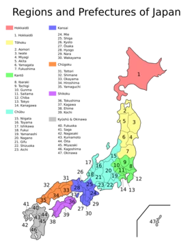
Fukushima Prefecture is a prefecture of Japan located in the Tōhoku region of Honshu, on the eastern Pacific coast. It is the third-largest prefecture in Japan by area and is divided by mountain ranges into three regions: Aizu, Nakadōri, and Hamadōri. The prefecture is historically significant as part of Mutsu Province and is known for the 2011 earthquake and tsunami that caused a nuclear disaster at the Fukushima Daiichi Nuclear Power Plant.
- population
- 1,771,100 (as of 1 July 2023)
- area
- 13,783.90 square kilometres (5,321.99 sq mi)
- capital
- Fukushima
- largest_city
- Iwaki
- region
- Tōhoku, Honshu, Japan
Verified Timeline
Lore & Background
Fukushima Prefecture has a history dating back to the Kofun period, with the keyhole-shaped Ōyasuba Kofun being the largest in the Tohoku region. Until the Meiji Restoration, the area was part of Mutsu Province. The Shirakawa Barrier and Nakoso Barrier were built around the 5th century. The Shiramizu Amidadō, a chapel built in 1160, is a National Treasure. The Fukushima Incident, a political tumult, occurred in 1882 after Mishima Michitsune was appointed governor.
Reader's Guide
Fukushima Prefecture is significant for its role in the 2011 Tōhoku earthquake and tsunami, which triggered a level 7 nuclear disaster at the Fukushima Daiichi Power Plant, the first such event since Chernobyl. The disaster led to widespread evacuation and long-term radiation concerns. The prefecture is also notable for its geography, including Lake Inawashiro, the fourth-largest lake in Japan, and Mount Bandai, the highest peak. Economically, Fukushima is a major producer of peaches, cucumbers, and sake, and is known for traditional crafts like lacquerware and Kokeshi dolls, which are said to have originated there. The prefecture's cultural heritage includes festivals such as the Sōma Nomaoi, a thousand-year-old samurai horse event, and the Waraji Festival featuring a giant straw sandal.
Did You Know?
- Fukushima Prefecture is the third-largest prefecture in Japan by area, after Hokkaido and Iwate Prefecture.
- Lake Inawashiro, located in the center of the prefecture, is the fourth-largest lake in Japan, covering 103.3 square kilometres.
- The Ōyasuba Kofun is the largest keyhole-shaped burial mound in the Tohoku region and was designated a National Historic Site in 2000.
- As of March 2011, Fukushima Prefecture produced 20.6% of Japan's peaches and 8.7% of its cucumbers.
- The Fukushima Daiichi nuclear disaster was upgraded to a level 7 event on April 11, 2011, the highest on the international scale, not seen since Chernobyl in 1986.
Geography & Regional Diversity
Fukushima Prefecture stretches across 13,784 square kilometres, making it the third-largest administrative division in Japan after Hokkaido and Iwate. Situated at the southern tip of the Tōhoku region on the Pacific coast, it is the closest prefecture in that northern cluster to Tokyo. Mountain ranges carve the territory into three distinct zones. The western Aizu region is defined by rugged terrain, dense forests, and heavy winter snowfall, sheltering scenic alpine lakes. The central Nakadōri zone serves as the agricultural backbone and houses the capital city of Fukushima. The eastern Hamadōri strip, bordering the Pacific Ocean, is the flattest and most temperate of the three. The prefecture's highest peak, Mount Bandai, rises to 1,819 metres, while the active stratovolcano Mount Azuma-kofuji, at 1,705 metres, anchors a cluster of hot spring resorts. Lake Inawashiro, sprawling across 103.3 square kilometres in the centre, ranks as Japan's fourth-largest body of fresh water. Because the prefecture sits along the Pacific Rim where the Pacific and Eurasian plates collide, tectonic activity remains a constant geological reality. As of April 2012, roughly thirteen percent of the total land area falls under protected status, encompassing Bandai-Asahi, Nikkō, and Oze National Parks alongside several quasi-national and prefectural parks.
The 2011 Earthquake, Tsunami & Nuclear Crisis
On the afternoon of March 11, 2011, a magnitude 9.0 earthquake struck off Miyagi's coast at 14:46 JST, sending seismic waves through Fukushima. Intensity readings varied dramatically: isolated pockets of the eastern Hamadōri coast registered a shindo of 6-upper, while the western Aizu region felt only a modest 2. The capital, Fukushima City, recorded a 6-lower. The quake triggered a devastating tsunami that battered the eastern shoreline, and structural failures including the collapse of Fujinuma Dam and widespread landslides compounded the destruction. Within two years, 1,817 residents had been confirmed dead or missing. The disaster's most consequential aftermath unfolded at the Fukushima Daiichi Nuclear Power Plant in Ōkuma, where the outer housings of two of the six reactors exploded and partial meltdowns and fires affected three additional units. Radiation near the plant spiked to 400 millisieverts per hour. On April 11, officials declared the event a level-7 incident, the highest on the international scale, a classification not reached since Chernobyl in 1986. Approximately 47,000 residents were evacuated. Months later, authorities permitted the gradual return of people living near the twenty-kilometre radial boundary, though the zone closest to the meltdown remained off limits.
History & Cultural Heritage
For centuries before the Meiji Restoration, the territory now known as Fukushima Prefecture fell under the jurisdiction of Mutsu Province. As early as the fifth century, the Shirakawa and Nakoso Barriers were erected as defensive lines to shield southern settlements from northern incursions. The Taika Reforms of 646 formally reorganised the area within Mutsu's administrative framework, and although brief provincial divisions called Iwase and Iwaki were created in 718, they reverted to Mutsu by the mid-720s. The region has also been referred to by the names Michinoku and Ōshū throughout its long history. Archaeologically, the keyhole-shaped Ōyasuba Kofun stands as the largest burial mound in the entire Tōhoku region and was granted National Historic Site status in 2000. In the medieval period, the Shiramizu Amidadō chapel, constructed in 1160 within the Ganjō-ji temple complex in Iwaki, earned National Treasure designation, and its surrounding paradise garden is likewise protected as a Historic Site. In the modern era, the prefecture experienced the Fukushima Incident, a political upheaval that erupted after Mishima Michitsune assumed the governorship in 1882, marking one of the region's more turbulent chapters in the early Meiji period.
Economy & Natural Resources
Fukushima's economy reflects the sharp contrast between its coastal and upland zones. Inland, the agricultural heart of the Nakadōri region and the mountainous Aizu zone focus on crop production. The prefecture's climate supports a remarkably diverse fruit-growing calendar: pears, peaches, cherries, grapes, and apples are cultivated throughout the year. By March 2011, Fukushima accounted for 20.6 percent of Japan's total peach output and 8.7 percent of its cucumber production, underscoring the region's agricultural significance. The prefecture is home to roughly 1.77 million residents as of mid-2023, spread across thirteen cities and numerous towns and villages. Iwaki holds the title of largest city by population, with Kōriyama a close second, followed by Aizuwakamatsu and Sukagawa as other significant urban centres. The capital, Fukushima City, sits in the southwestern portion of the Fukushima Basin, nestled among nearby mountains, and serves as the administrative and commercial hub. The combination of marine resources, agricultural output, and energy production gives the prefecture a diversified economic profile that spans from the ocean to the alpine interior.
Frequently Asked Questions
Who is Fukushima Prefecture?
Fukushima is the third-largest prefecture by land area in all of Japan, sitting along the eastern Pacific coastline of Honshu in the Tōhoku region. Its administrative seat is the city of Fukushima, while Iwaki serves as the most populous urban center.
What are Fukushima Prefecture's powers/role?
The prefecture is split by its mountain ranges into three distinct zones—Aizu, Nakadōri, and Hamadōri—giving it a varied landscape that stretches from alpine lakes like Lake Inawashiro to coastal farmland. It is also a major producer of fruit and carries deep historical roots in the old Mutsu Province.
How does Fukushima Prefecture's story end?
The 2011 earthquake and tsunami triggered the nuclear accident at the Daiichi plant, an event that permanently reshaped the prefecture's modern identity. Recovery and decontamination work are still underway, yet the region continues to rebuild around its agricultural output and natural heritage.
Why is Fukushima Prefecture important?
Beyond being a Tōhoku-region hub with roughly 1.77 million residents spread across nearly 13,800 square kilometres, it carries the weight of hosting Japan's most significant nuclear catastrophe. Its geography and layered history make it a key reference point for understanding both regional identity and national energy policy.
What is Fukushima Prefecture most known for?
Fans and visitors most often associate the prefecture with the 2011 nuclear disaster, the scenic Lake Inawashiro, and its reputation as a top fruit-growing area. It also preserves the legacy of the ancient Mutsu Province, giving it a rich cultural depth beyond the headlines.
More in Japanese Prefectures 1-24
Elsewhere in the Japanese Prefectures universe
Spotted an error? Know more?
This is a living reference — every entry is fact-audited, and reader corrections feed straight into our audit queue. Suggest an edit · See this site's audit record